|
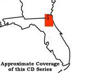
Historic Topographic Quadrangles of Northeast Florida
Including parts of Clay,
Duval, Nassau and St. Johns Counties.
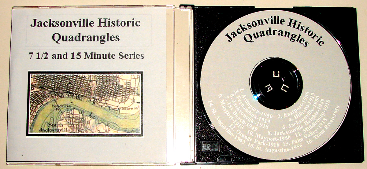
This series of 15-minute quads was surveyed in 1918-19. The 7.5-minute series was surveyed during 1949-56. These maps are an excellent source of history and can be
used to study predecessor and abandoned railroads, as well as, ghost towns of yesteryear. These very rare maps have been digitized and the complete series is
available on CD. All 16 maps shown on this page are available in extremely high resolution JPEG format on a single CD. Image sizes range from 4 - 10 meg in
compressed JPEG format. When opened they range from 70-240 meg each. Exceptional quality and detail. A very small sample portion of the 15-minute 1918 Jacksonville
quadrangle is shown below. The CD is available for the nominal price of $26.95 postpaid (within the U.S.) See the ordering information at the bottom of this
page.
|
|
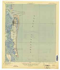
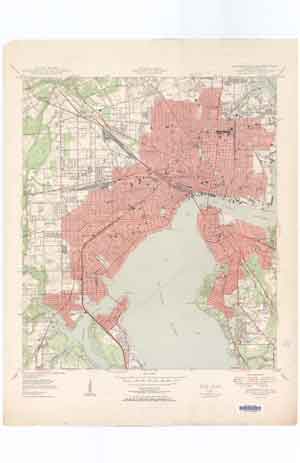
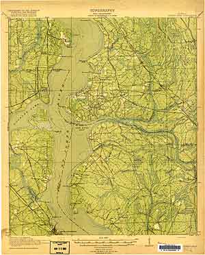
Sample portion from the 1918 Jacksonville Quadrangle:
(this sample is in a medium resolution JPEG format, the images on the CD
are higher resolution and quality)
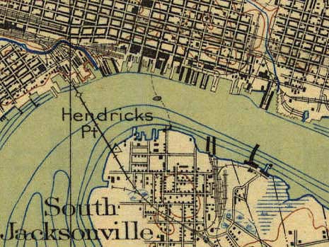
Sample from USGS Jacksonville 1918 Quadrangle
|
|
|
A CD version of
"Jacksonville Historical Quads CD"
is available from Platform 3 Research
for $26.95 postpaid. The CD includes
full-color, hi-resolution .JPG format images.
|
Order the CD direct from Platform 3 Research $26.95 Post Paid
(Iowa orders with 7% sales tax: $28.83)
(post-paid within the U.S.; additional postage required for shipping outside the U.S.; Iowa Orders must include 7% Iowa sales tax)
 Platform 3 Research accepts Paypal, Credit Cards(via Paypal) and Money Orders
To order via Paypal or credit card, click the "BUY NOW" button below. For additional ordering information,
international orders, or instructions on ordering via MONEY ORDER, contact Platform 3 Research by clicking the Email link below.
|
Order Here (choose shipping address below):
|
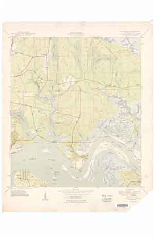
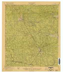
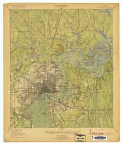
Thumbnail views of the 16 maps contained in this collection: |
|
USGS Arlington 1950 7.5-minute Quadrangle
Portion of Duval County Florida. Department of the Army, Corps. of Engineers.
Includes the following towns and villages:
Gilmore, Florida; Cosmo, Florida; Floral Bluff, Florida, Arlington, Florida;
Oakwood Villa, Florida; Spring Glen, Florida; Hogan, Florida; Bowden, Florida;
Newcastle, Florida; Eggleston Heights, Florida; Southside Estates, Florida;
Center Park, Florida.
Other features shown:
Parsons cemetery; Cosmo cemetery; Gilmore cemetery;
Mt. Zion Church; Arlington cemetery; School 46; School 125; Sammis cemetery; Lake Tresca; Greenlawn cemetery; Hunter Park Church; School 64; Shiloh Church; Flaggler Lookout Tower; Florida East Coast rail yards; Pauline Island; Newcastle Creek; Southern Pond; Mitchell Bluff; Marian Island; Rush Island; Bird Island; Mill Cove; Lake Narcissus; Lake Effie; St. Johns River; Lake Lucina; Holly Oaks Lake; Cowhead Creek; Cedar Swamp; Craig Airfield; Ginhouse Creek; Jones Creek; Strawberry Creek; Red Bay Branch; Empire Point; Arlington River; Silversmith Creek; Pottsburg Creek; Little Pottsburg Creek; Ryals Swamp; Wolf Bay; Boggy Branch; Buck Head Branch; Sawmill Slough; Mill Dam Branch; Big Island Swamp; Third Puncheon Branch; Second Puncheon Branch; First Puncheon Branch; Tiger Hole Swamp; Bennett Branch.
|
USGS Fernandina 1919 15-minute Quadrangle
Portions of Camden County Georgia, Nassau County Florida, and Duval County
Florida. War Department, Corps. of Engineers, U.S. Army; R.B. Marshall, Chief Geographer; W.H. Herron, Geographer in Charge; C.W. Goodlove, Topography;
U.S. Coast and Geodetic Survey Corps of Engineers U.S. Army: R.G. Clinite and C.B. Kendall.
Includes the following towns and villages:
Dungeness, Georgia; Old Fernandina, Florida, Fernandina, Florida;
Black Hammock, Florida; Franklintown, Florida.
Other features shown:
U.S. Quarantine Station; McClure Hill; Fort Clinch; Crane
Island; Cumberland Sound; St. Marys River; Cumberland Island; Beach Creek; Jolly River;
Tiger Creek; Tiger Island; Ameilia Island Lighthouse; St. Joseph Creek; Lanceford Creek;
Bells River; Soap Creek; Amelia River; Jackson Creek; Kingsley
Creek; Amelia Island; Alligator Creek; Harrison Creek; Walker Creek; South Amelia River; Back River; Nassau River; Middle Marsh; Nassau Sound; Sawpit Creek;
Black Hammock Island; Pumpkin Hill Creek; Talbot Island.
|
|
USGS Eastport 1950 7.5-minute Quadrangle
Portion of Duval County Florida.
Includes the following towns and villages:
Duval, Florida; Polly Town, Florida; Eastport, Florida; Fulton, Florida;
Dame Point, Florida; New Berlin, Florida; Chaseville, Florida.
Eulalia, Florida;
Other features shown:
Hutto Chapel; Dunns Creek Church; Dunn Creek cemetery;
Oak Grove Chruch; Bethel Church; St. Marks Church; Caney Swamp; Sample Swamp; Clapboard Swamp; Caney Branch; Pelotes Road; Sawpit Road; Bogey Branch; Buckhorn Bluff; Clapboard Creek; Rushing Creek; Sweetwater Creek; Jacksonville Municipal Airport Dunn Creek; Terrapin Creek; Browns Island; Pelotes Island; Fitzpatrick Creek; St. Johns River; Round Top; Browns Creek; Vicks Island; San Carlos Creek; Nichols Creek; New Berlin School; Broward Point; Drummond Point; Broward River; Drummond Creek; Little Marsh Island; Le Baron Island; Coon Point; Alligator Island; Reddie Point; Crab Island; Willian Island; Randolph Island; New Castle Island; Quarantine Island; Radcliffe Island; Back River; Alligator Creek; Shipyard Creek; Live Oak Creek; Mill Cove; Reed Island; Fip Island; Pauline Island.
|
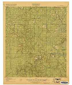
USGS Hilliard 1919 15-minute Quadrangle
Portions of Nassau County Florida and Duval County Florida.
War Department, Corps. of Engineers, U.S. Army; Department of the Interior, Franklin K. Lane, Secretary; George Otis Smith, Director; R.B. Marshall, Chief Geographer; W.H. Herron, Geographer in Charge; Glenn S. Smith, Topgraphic Engineer in charge of Military Surveys; J.H. Jennings, Topography; U.S. Coast and Geodetic Survey Corps of Engineers U.S. Army: W.S. Gehres, C.B. Kendall, J.B.Leavitt, and E.L McNair.
Includes the following towns and villages:
Andrews, Florida; Lessie, Florida; Hilliard, Florida;
Cummers Camp, Florida; Dyal, Florida; Nelsons Mill,
Florida; Callahan, Florida; Kent, Florida; Crawford,
Florida; Hodges Mill, Florida; Ratliff, Florida.
Other features shown:
Brickyard School; Romulus School; Wilder Swamp School;
New Hope School; Boggy Swamp School; Mill Creek School;
Drurys Ferry Road; Brushy Creek; Pigeon Creek; Whiteoak Swamp; Wilder Swamp; Little St. Marys River; Little Dunn Creek; Little Boggy Swamp; Cross Branch; Spell Swamp; Boggy Swamp; Mills Swamp; Little Mills Swamp; Alachua Trail; Alligator Swamp; Mill Creek; Thomas Creek; St. George and Jacksonville Road; Georgia Southern and Florida Railroad.
|
|
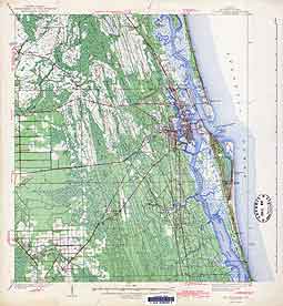
USGS Jacksonville 1918 15-minute Quadrangle
Portion of Duval County Florida.
War Department, Corps. of Engineers, U.S. Army; Department of the Interior, Franklin K. Lane, Secretary; George Otis Smith, Director; R.B. Marshall, Chief Geographer; W.H. Herron, Geographer in Charge; Glenn S. Smith, Topgraphic Engineer in charge of Military Surveys; J.H. Jennings, Topography; U.S. Coast and Geodetic Survey Corps of Engineers U.S. Army: W.S. Gehres, C.B. Kendall, J.B.Leavitt, and E.L McNair.
Includes the following towns and villages:
Duval, Florida; Dosin, Florida; Broward, Florida; Riverview, Florida;
Eastport, Florida; New Berlin, Florida; Fulton, Florida; Gilmore, Florida;
Chaseville, Florida; Eulalia., Florida; Dames Point, Florida;
Panama Park, Florida; Oakhurst, Florida, Pride City, Florida;
Pickett, Florida; Grand Crossing, Florida, Moncrief Station, Florida;
Brentwood, Florida, New Springfield, Florida; Phoenix Park, Florida;
Long Branch, Florida; Eggleston Heights, Florida; Floral Bluff, Florida;
Jacksonville, Florida; Brooklyn, Florida; Highway, Florida;
Arlington, Florida; Arlington Heights, Florida; Spring Glen, Florida;
St. Nicholas, Florida; Phillips, Florida; South Jacksonville, Florida;
Murry Hill, Florida; Lakeside Park, Florida; St. Johns Park, Florida;
HoHingwood, Florida; Hogan, Florida; Center Park, Florida; Skinner,
Florida; Bowden, Florida; Ortega, Florida.
Other features shown:
Braddock School; Utto Chapel School; Dunn Creek School; City Prison
Farm; Turner Pond; Drummond Point; Mitchell Bluff; Reddie Point;
Sandfly Point; Winter Point; Florida Military Academy; Flagler
Preparatory School; Sadler Point; Phillips Point; County Prison Farm;
Florida East Coast Mayport Branch; Christopher Point; Caney Branch; Wolf Bay; Yulee Road; Sweetwater Creek; Rushing Branch; Clapboard Creek; Cedar Creek; Half Creek; Trout Creek; Dunn Creek; Terrapin Creek; San Carlos Creek; Browns Island; Roundtop; Pelotes Island; Little Clapboard Creek; Vicks Island; Browns Creek; Coon Point; Broward Point; Drummond Point; Ninemile Creek; St. Johns River; Rudolph Island; Crab Island; William Island; Newcastle Island; Calder Creek; Quarantine Island; Alligator Island; Radcliffe Island; Alligator Creek; Long Island; LeBaron Island; Little Marsh Island; Mill Cove; Bird Island; Mariam Island; Rush Island; Mitchell Bluff; Pauline Island; Fip Island; Long Branch; Moncrief Creek; Sixmile Creek; Cowhead Creek; Ginhouse Creek; Jones Creek; Gainesville Road; Winter Point; Hendricks Point; Commodore Point; Empire Point; Arlington River; Silversmith Creek; Mill Creek; Pablo Beach Road; Florida East Coast Mayport Branch; Pottsburg Creek; Little Pottsburg Creek; Hogan Creek; Sadler Point; Cedar Creek; Williamson Creek; Orange Park Road; Phillips Point; Christopher Creek; St. Augustine Road; Christopher Point; Orange Park Road; McGirts Creek; Fishing Creek; Old Orange Park Road.
|
USGS Jacksonville 1950 7.5-minute Quadrangle
Portion of Duval County Florida.
Includes the following towns and villages:
Pickettville; Grand Crossing; St. Nicholas; South Jacksonville; Larsen; Ortega; Venetia.
Other features shown:
Ribault River; Edgewood Cemetery; Kings Road; Moncrief Creek; Municipal Golf Course; Andrew Jackson High School; Evergreen Cemetery; Long Branch; St. Johns Terminal Railroad; St. Johns River; Minicipal Terminal Railroad; Northeast Springfield School; Beaman School; Davis Street School; Brentwood Park; Williams Flying School; Edward Waters College; Mt. Herman Cemetery; Darnell Cookman School; County Hospital; Springfield Park; Hogan Creek; Gilbert School; Deer Creek; Oakland School; Confederate Park; Lewis Jr. High School; Jacksonville School of Technology; County Farm; Lackawanna School; McCoy Creek; Union Station; Central School; East Jacksonville School; Fairfield School; Commodore Point; St. Johns River; Hendricks Point; Lytle School; Riverside Park; Gorrie Jr. High School; Upson School; Robert E. Lee High School; West Riverside School; Memorial Park; Winter Point; Marco Lake; Landon High School; Spring Park School; Miller Creek; Craig Creek; Little Fishweir Creek; Wills Branch; WJAX Radio Tower; Big Fishweir Creek; Fishweir School; Boone Park; Hendricks Avenue School; Point La Vista; Sadler Point; Lake Shore School; Williamson Creek; Cedar River; Ortega River; Oaklawn Cemetery; Christopher Creek; Fishing Creek; Butcher Pen Creek; Blanding Highway; Yacht Basin; Christopher Point; Alfred I. Dupont School.
|
|
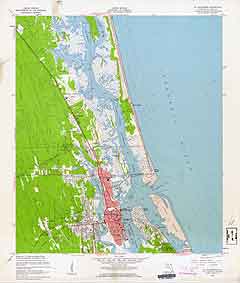
USGS Jacksonville Beach 1949 7.5-minute Quadrangle
Portions of Duval County Florida and St. Johns County Florida.
Includes the following towns and villages:
Manhattan Beach, Florida; Wonderwood, Florida; Greenfield, Florida;
Donner, Florida; Atlantic Beach, Florida; Neptune Beach, Florida;
San Pablo, Florida; Jacksonville Beach, Florida; Oak Landing, Florida.
Other features shown:
Mayport cemetery; Spanish Point; Tillotson cemetery; Atlantic Beach
School; Fletcher High School; School No. 144; Warren Smith
cemetery; El Verde Yacht Basin; Huguenot Lagoon; Ponte Vedra Golf Course; Tiger Pond; Mud Flats Creek; Mt. Pleasant Creek; Four Pines Island; Greenfield Islands; Chicopit Bay; Buckhorn Creek; Dawson Island; Pablo Creek; Boathouse Creek; Boathouse Islands; Buck Island; Wild Cow Island; Indian Mounds; Old Sherry Drive; Sherman Creek; Puckett Creek; Garden Creek; Cemetery Creek; Matthews Island; Greenfield Creek; Tiger Pond Creek; Possum Head Swamp; Cedar Swamp; De Blieu Creek; Pine Island; Kestner Creek; Crying Child Island; Hopkins Creek; Seven Pines Island; Hogpen Creek; WJVB Radio Tower; Old Kings Highway; Cradle Creek; Beswick Island; Ryals Swamp; Open Creek; Boggy Branch; Sandy Run; Cut Creek.
|
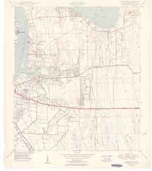
USGS Jacksonville Heights 1949 7.5-minute Quadrangle
Portions of Clay County Florida and Duval County Florida.
Includes the following towns and villages:
Jacksonville Heights, Florida; Federal Hill, Florida.
Other features shown:
Mile Branch Landing Field; Cecil Naval Auxiliary Air Station;
Brannon Outlying Air Field; Ortega Creek; Taylor Creek; Little Black Creek.
|
|
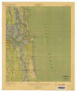
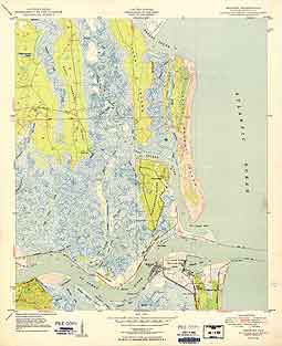
USGS Mayport 1918 15-minute Quadrangle
Portions of Duval County Florida and St. Johns County Florida.
War Department, Corps. of Engineers, U.S. Army; Department of the Interior, Franklin K. Lane, Secretary; George Otis Smith, Director; R.B. Marshall, Chief Geographer; W.H. Herron, Geographer in Charge; J.H. Jennings and W.L. Miller, Topography; U.S. Coast and Geodetic Survey Corps of Engineers U.S. Army: W.S. Gehres and C.B. Kendall.
Includes the following towns and villages:
Pilot Town, Florida; Fort George, Florida; East Mayport, Florida;
Coquina, Florida; Mayport, Florida; Manhattan Beach, Florida;
Atlantic Beach, Florida; Greenfield, Florida; Neptune, Florida;
Cashens, Florida; Manatee Avenue, Florida; San Pablo Station, Florida;
Pittville, Florida; Pablo Beach, Florida;
Other features shown:
Talbot Island; Little Talbot Island; Mt. Cornelia; Ft. George Post
Office; Fort George Island; Coquina Post Office; St. Johns Bluff;
Weldbow Landing; Boathouse Landing; Salamander Landing; Florida
East Coast Railway Mayport branch; Sawpit Creek; Nassau Sound; Long Island; Simpson Creek; Pumpkin Hill Creek; Gunnison Cut; Broward Creek; Mud River; Cedar Point; Clapboard Creek; Fitzpatrick Creek; Garden Creek; Ft. George River; Fort George Inlet; Haulover River; Sister Creek; Shell Island; Sister Island; Pine Island; Hannah Mills Creek; Cedar Point Creek; Little Marsh Island; St. Johns River; Fanning Island; St. Johns Point; Sherman Creek; Sherman Point; Mile Point; Great Marsh Island; Colorinda Creek; Mt. Pleasant Creek; Greenfield Creek; Pablo Creek.
|
USGS Mayport 1950 7.5-minute Quadrangle
Portion of Duval County Florida.
Includes the following towns and villages:
Fort George, Florida; Mayport, Florida; East Mayport, Florida.
Other features shown:
Half Moon Bluff; Talbot Island; Little Talbot Island; Cabbage
Hammock Swamp; Black Hammock Island; Anderson cemetery;
Coon Keys; Cedar Point; Mt. Cornelia; Fort George Island;
Wards Bank; St. Johns Point; Ribault Bay; U.S. Coast Guard
Training Station; Fanning Island; Chicopit Bay; Ribault Monument; Tiger Point; Sawpit Creek; Nassau Sound; Middle Bank; Pumpkin Hill Creek; Gunnison Cut; Simpson Creek; Myrtle Creek; Long Island; Broward Creek; Greys Swamp; Mud River; Simpson Creek; Fort George River; Garden Creek; Sisters Creek; Horseshoe Creek; Fitzpatrick Creek; Clapboard Creek; Round Pond; Deep Creek; Cedar Point Creek; Fort George Inlet; Batten Island; Shad Creek; Sisters Island; Shell Island; Hannah Mills Creek; Little Marsh Island; Pine Island; Fanning Island; Seminole Beach; Mile Point; St. Johns River; Dark Entrance; St. Johns Creek; St. Johns Bluff; Colorinda Creek; Chicopit Bay; Great Marsh Island; Chicopit Bay; Sherman Point; Sherman Creek;
|
|
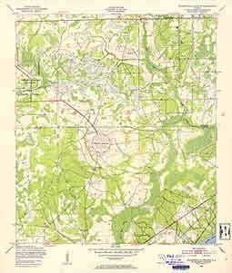
USGS Middleburg 1918 15-minute Quadrangle
Portions of Duval County Florida and Clay County Florida.
War Department, Corps. of Engineers, U.S. Army; Department of the Interior, Franklin K. Lane, Secretary; George Otis Smith, Director; R.B. Marshall, Chief Geographer; W.H. Herron, Geographer in Charge; W.S. Gehres, Fred Graff Jr., J.H. Jennings, J.B. Leavitt and Gilbert Young, Topography; Corps of Engineers U.S.A.: W.S. Gehres and C.B. Kendall.
Includes the following towns and villages:
Fiftone, Florida; Pelham, Florida; Peoria, Floria; Rideout, Florida; Federal Hill, Florida; Doctors Inlet, Florida; Middleburg, Florida; Russell, Florida.
Other features shown:
Garden City School; Bristol Bridge; Bell School;
Clay Hill School; Duckpond School; Hatcherville School;
Rideout School; Rideout Ferry; Rattle Snake Island; Tritt Bridge;
George Carter School; Moss Ferry; Pinegrove School; Russell School;
Black Creek Church; Oxpass School; Dowling Bridge; Sunnyside School; Caldwell Branch; Heber Tramroad; Gainesville Road; Moore Branch; Rowell Branch; Sal Taylor Creek; McGirts Creek; Big Branch; Yellow Water Creek; Camp Branch; Long Branch; Black Creek; Mill Branch; Wheeler Branch; Clay Hill Road; Doctors Lake; Little Black Creek; Grog Branch; Rattlesnake Island; Duck Water Branch; North Fork; Boggy Branch; Lawtey Road; Dillaberry Branch; Moss Ferry; Phillips Cove; Mill Log Creek; Bradley Creek; Polander Branch; Mill Creek; Starke Road; Bull Creek; South Fork; Peters Creek; Green Cove Springs Road; Camphor Farm Road.
|
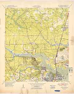
USGS Orange Park 1918 15-minute Quadrangle
Portion of Clay County Florida, St. Johns County Florida
and Duval County Florida. War Department; Corps of Engineers, U.S. Army; Department of the Interior, Franklin K. Lane Secretary; George Otis Smith, Director; R.B. Marshall, Chief Geographer; Frank Sutton, Geographer in Charge; Glenn S. Smith, Topographic Engineer-Military Surveys; Fred Graff Jr., Topography; Gilbert Young, Topography; U.S. Coast and Geodetic Survey, Corps. of Engineers U.S. Army: W.S. Gehres, C.B. Kendall, J.B. Leavitt.
Includes the following towns and villages:
Yukon, Florida; Stockade, Florida; Sunbeam, Florida;
Plummers, Florida; Reeds Crossing, Florida; Orange Park, Florida;
Mandarin, Florida; Loretto, Florida; Greenland, Florida; Bayard,
Florida; East Mandarin, Florida; Fruit Cove, Florida; Pine Bluff,
Florida; Pinehurst, Florida; Ophir, Florida; Switzerland, Florida;
Cuckoo, Florida; Russell, Florida; Hibernia, Florida; New Switzerland
Point, Florida; Julia, Florida, Orangedale, Florida; Remington
Park, Florida; Self, Florida; Magnolia Springs, Florida; Green
Cove Springs, Florida; Durbin, Florida.
Other features shown:
Black Point; Christopher Point; Old Kings Road; Bethel Church;
BeauClerc Bluff; Mulberry Grove; Deep Bottom School; Ruter Ford;
Flat Ford; Mandarin Point; Swimming Pen School; Old Bull Bay;
Retort; Julington School; Sampson School; Glenwood Chruch; St.
Johns Church; Neals Dock; Whites Ford; Popo Point; Magnolia Point;
Durbin Post Office; Fishing Creek; Piney Point; Lumber Tramroad; Gum Swamp; Goodbys Creek; St. Johns River; McGirts Creek; Old Jacksonville Road; Plummers Point; Plummers Cove; Sweetwater Creek; Big Davis Creek; Doctors Lake; Julington Creek; Corklan Branch; Durbin Creek; Flora Branch; Ragget Point; Swimming Pen Creek; Cunningham Creek; Bowen Branch; Flat Swamp; Fever Hammock; Little Lige Branch; Big Lige Branch; Mill Creek; Cartwheel Bay; Sampson Creek; Gopher Island; Cedar Head; Pecks Branch; Peters Creek; Black Creek; Wilkies Point; Molasses Branch; Trout Creek; Tar Landing; Petty Branch; Kendall Creek; Governors Creek.
|
|
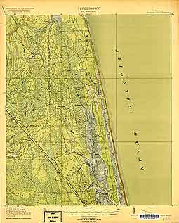
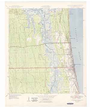
USGS Palm Valley 1918 15-minute Quadrangle
Portions of Duval County Florida and St. Johns County Florida.
War Department; Corps of Engineers, U.S. Army; Department of the Interior, Franklin K. Lane Secretary; George Otis Smith, Director; R.B. Marshall, Chief Geographer; W.H Herron, Geographer in Charge; Fred Graff Jr., W.L. Miller, M.A. Roudabush and Gilbert Young, Topography; U.S. Coast and Geodetic Survey, Corps. of Engineers U.S. Army: W.S. Gehres, C.B. Kendall, J.B. Leavitt.
Includes the following towns and villages:
Dewey, Florida; Crackertown, Florida; Palm Valley, Florida;
West Landing, Florida; Willacoochee Landing, Florida; Perkins
Landing, Florida; Clarksville, Florida; Twentymile, Florida;
Durbin, Florida; Hilden, Florida; Shell Bluff Landing, Florida;
Sampson, Florida; South Durbin, Florida.
Other features shown:
Meyer Landing; Loring Landing; Cooks Landing; Sampson Church;
Booths Landing; Pablo Creek; Reedy Branch; Box Branch; Florida East Coast Canal; Big Davis Creek; Diego Plains; Cabbage Swamp; Durbin Swamp; Powers Bay; Scrub Ridge; Dry Swamp; Ragged Island; Durbin Creek; Smith Creek; Guano River; Sampson Creek; Deep Creek; Sweetwater Creek; North River; Marshall Creek; Twelvemile Swamp; Big Island.
|
USGS St Augustine 1943 15-minute Quadrangle
Portion of St. Johns County Florida. Surveyed in 1937. Topography: J.B. Leavitt; G.E. Sisson, J.K. Bailey, A.G. England, H.J. McMillen and H.R. Kilmer.
Includes the following towns and villages:
Casa Cola, Florida; Araquey, Florida; Usinas Beach;
Vilano Beach; Mt. Pleasant, Florida; Bakersville, Florida;
Glimpse of Glory, Florida; West St. Augustine, Florida;
St. Augustine, Florida; Davis Shores, Florida; Lighthouse
Reservation, Florida; Anastasia, Florida; College Park, Florida;
Tocoi Junction, Florida; St. Augustine Beach, Florida; Coquina Gables,
Florida; Moultrie, Florida; Fort Peyton, Florida; Vermont, Florida;
Vermont Heights, Florida; Elkton, Florida; Mickler, Florida;
Crescent Beach, Florida; Dupont Centre, Florida; Armstrong, Florida.
Other features shown:
Capos Island; Mill Creek School; Red Buck Island; Six Mile Neck;
Fountain of Youth Park; Vilano Point; Fort Marion National Monument; Crazy Bank; Bird Island; San Lorenzo cemetery; State Normal Institute; Fishers Island; St. Paul Chruch; Moultrie Church; Lewis Point; Hughes cemetery; St. Ambrose School; Fotch Island; Mill Creek; Ninemile Road; Mill Creek Road; Twelvemile Swamp; Simone Island; St. Marks Pond Swamp; Guano River; Ocean Shore Boulevard; Toleomato River; St. Augustine Golf Club; Dixie Highway; St. Augustine Airport; Old Kings Road; Masters Island; Turnbull Swamp; Turnbull Creek; Pacetti Road; Picolata Road; Sixmile Swamp; Fivemile Swamp; Fourmile Swamp; Red House Branch; State Deaf and Blind Institute; Kurths Island; Robinson Creek; St. Augustine Inlet; Macaris Creek; San Sabastin River; Trestle Bay Swamp; Cowan Swamp; Tocoi Road; Anastasia Island; Matanzas River; McCullough Creek; Moultrie Creek; Moses Creek; Moccasin Branch; Tocoi Elkton Road; Fotch Island; Hastings Street.
|
|
USGS St. Augustine 1956 7.5-minute Quadrangle
Portion of St. Johns County Florida.
Includes the following towns and villages:
Usinas Beach, Florida; Araquey, Florida; Woodlawn, Florida;
Vilano Beach, Florida; Davis Shores; St. Augustine, Florida;
Moultrie Junction, Florida; Anastasia, Florida; College Park, Florida.
Other features shown:
Fairchild Airfield; Mt. Pleasant cemetery; Ponce De Leon Golf Club; Comatchie Island; Vilano Beach Bridge; State Deaf and Blind
Institute; Fountain of Youth Park; Vilano Point; Castillo De San
Marcos National Monument; Woodlawn cemetery; Murray High School;
Florida Industrial College; Maria Sanchez Lake; Bridge of Lions;
State Arsenal; Bird Island; Anastasia State Park;
Flagler Memorial Hospital; Capos Island; Tolomato River; Guano River; Sombrero Creek; Casa Cola Creek; Ximanies Creek; Indian Creek; Pancho Creek; Robinson Creek; Kurths Island; Red House Branch; St. Augustine Inlet; San Sebastian River; Hospital Creek; Conch Island; Anastasia Island; St. Joesephs Academy; Oyster Creek; Matanzas River; Quarry Creek; Salt Run.
|
USGS Trout River 1950 7.5-minute Quadrangle
Portion of Duval County Florida.
Includes the following towns and villages:
Duval, Florida; Beeghly Heights, Florida; Oceanway, Florida;
Browards Station, Florida; Garden City, Florida; Beverly Hills,
Florida; Holly Ford, Florida; Lake Forest, Florida; Riverview,
Florida; Jacksonville, Florida.
Other features shown:
Jacksonville Municipal Airport; City Prison Farm; Turner Pond; Friendship Church; Potters Field; Greenwood cemetery; Restlawn
Memorial Park; Three Graces Chruch; Pinehurst cemetery; Pickett
cemetery; Sandfly Point; Mt. Calvary Church; Memorial cemetery; Pickett School; Wolf Bay; Little Cedar Creek; Cedar Creek; Gulley Branch; Half Creek; Broward River; Blockhouse Creek; West Branch; Trout River; Ninemile Creek; Drummond Creek; Ribault River; St. Johns River; Moncrief Creek.
|